|
 |
 |
|
 Demeke Shumeye Lakew Demeke Shumeye Lakew |
 Quang Tuan Do Quang Tuan Do |
|
|
|
 |
 |
 |
|
|
LEO Satellite Networks
|
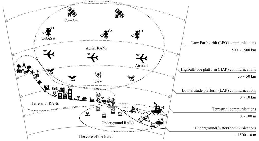
| Current network access infrastructures are characterized by heterogeneity, low latency, high throughput, and high computational capability, enabling massive concurrent connections and various services.
Unfortunately, this design does not pay significant attention to mobile services in underserved areas and special events. For instance, event-based communications where vast numbers of users assemble in one location (e.g., concerts, festivals,
stadiums, and squares), which require a tremendous increase in network service connections for a short time, thereby potentially overloading existing communication infrastructure. Another important case is disaster communications in which network
infrastructure may be damaged or destroyed and thus rendered unable to provide service, nonetheless communication remains critical to support search and rescue (SAR) operations. From another perspective, scheduled communications may iteratively
establish services as planned periodically, such as environmental sensing reports in intelligent agriculture and aerial forest surveillance. A fixed infrastructure is not necessarily suitable for such scenarios, which call for a mobile portable
infrastructure instead. Finally yet importantly, sparsely populated communities (e.g., in isolated areas and at sea) especially would benefit from improved Internet access capabilities for emergency and informational communications. Thus, by leveraging the
the fundamental advantage of aerial networking infrastructures, including mobility, better channel access, improved coverage, and a higher probability of line-of-sight (LoS) signal propagation compared to terrestrial networks serve as a promising foundation
to overcome the current challenges. To support various application scenarios, multiple UAVs may collaborate and establish different networking topologies including mesh, star, bus, and hierarchical architectures with respect to the communication requirements
and the capabilities of the UAVs. Conversely, satellite communications have been exploited to provide users with internetworking services in remote areas for the last decade. In this system, ground stations typically act as transfer nodes that connect to the
satellite constellation and relay communications to user devices. The above observation leads to the necessity of studying current proposals and reorganizing such aerial access architectures toward a comprehensive access infrastructure for 6G networks. |
 |
|
|
|
|
Flying Ad-Hoc Networks (FANET)
|
|
Unmanned aerial vehicle (UAV) systems that can fly autonomously or can be operated remotely without carrying
any human personnel have been made possible thanks to the rapid technical advancements in electrical, sensor, and communication
technology. The use of UAVs promises new approaches for both military and civilian applications, such as search and destroy
operations, border surveillance, managing wildfires, relay for ad hoc networks, wind estimation, disaster monitoring, remote
sensing, and traffic monitoring, thanks to their adaptability, simplicity, ease of installation, and relatively low operating
costs. Although single-UAV systems have been in use for many years, there are several benefits to deploying a number of tiny
UAVs as opposed to creating and managing a single large UAV.
|
|
|
|
| Research Topics and Broader Impact |
| (1) Search and Rescue (SAR) |
| (2) Environmental sensing |
| (3) Relaying network |
| (4) Broader Impact |
|
|
|
|
| (1) Search and Rescue (SAR) |
|
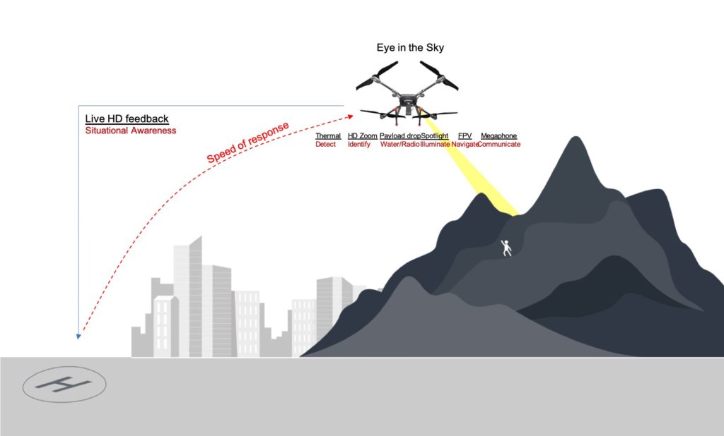
In the search and rescue context, UAVs are looking/sensing for a target, typically on the ground. UAV networks were first employed for search and rescue operations during Hurricane Katrina in 2005, and later in the Fukushima disaster in 2011 and the Nepal earthquake in April 2015. The system is used to assess areas that are inaccessible to people and to find potential survivors by detecting wireless signals from victims' mobile phones. In order to reduce the amount of time it takes to find some victims, various search tactics are investigated. These tactics are discussed while taking into account crucial elements like the caliber of the sensors, energy limitations, the presence of obstacles, and the model of UAV communication.
|
|
The type of infrastructure to be used has a significant impact on the mobility behavior of UAVs because there are so many different contexts in which search operations can be implemented. The search area is typically predetermined at the beginning of the operation so that each UAV can have a predetermined search path. UAVs must always be connected to a base station if the operation is being watched over by one, forming a relaying chain. As a result, all paths must be planned so that the network remains connected at all times. When planning a rescue mission, several obstacles must be taken into account if the search operation is conducted in a mountainous area. In emergency situations, the rescue base requires real-time (audio and video) information about the area. This places restrictions on collaborative UAV networking, such as the connectivity level that can ensure service continuity.
|
 |
|
|
|
|
| (2) Environmental Sensing |
|
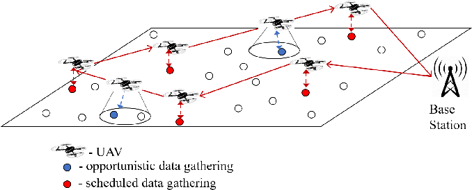
A sensor network is a set of sensors arranged in proximity or within the phenomenon to be observed. These sensors are characterized by limited energy consumption, small sizes, and low costs. Temperature, humidity, pressure, light intensity, or pollution levels are typical physical quantities that a sensor network can analyze. Recently, UAVs are increasingly being used in sensor networks, and this growth is largely due to the heterogeneous nature of flying objects, which can be outfitted with various kinds of sensors and other tools. UAVs can be used to collect data from wireless sensor networks. We must put in place an algorithm for effective UAV deployment in order to accomplish that. Using wireless sensors to collect data, the UAVs fly autonomously through the target area before returning to base to be analyzed later.
|
|
UAVs typically only move when necessary to get to their intended locations in the air or close to the ground. After that, they stay still to sense a particular aspect of the environment. As an alternative, they can follow a predetermined plan of movement. Data transmission over the FANET is not always necessary. UAVs have sensors that can gather environmental data, which they can then store; when they get back to the base station, the data can be downloaded in a matter of seconds. Instead, UAVs must be connected to one another in order to perform real-time sensing. Instead of audio or video, the sensed data typically include information about the environment (temperature, humidity, pollution, etc.). Therefore, high throughput is not required.
|
 |
|
|
|
|
| (3) Relaying Network |
|
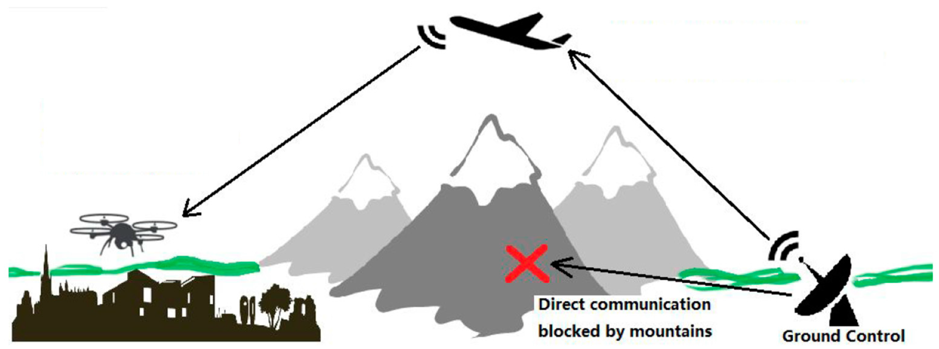
Autonomously operated UAVs are being used as airborne communication relays to efficiently and securely transmit the information collected by ground devices to distant control centers, for example, the delivery of data produced by wireless sensor network (WSN) nodes on the ground to the user. UAVs can also be used for increasing the communications range of ground relaying nodes, including Internet-of-vehicles (IoV) scenarios.
|
|
In order to provide connectivity between the end users/nodes, UAVs acting as relay nodes deploy some backbones that reach those nodes. As there is no compelling reason for UAVs to move in space while maintaining connectivity, these backbones typically have very low mobility. In fact, network performance improves as drones become more static. Even yet, there are situations where the backbone's end nodes must track moving objects to ensure connection with them (such as rescue personnel or victims in disaster zones), but mobility is still restricted to the end nodes and is characterized by slow speeds. UAVs can act as gateways that go along the streets if the targets to be covered are moving quickly, such as in the event of preserving connectivity among cars (for example, in smart city scenarios).
|
 |
|
|
|
|
| (4) Broader Impact |
|
The presence of FANET provides new opportunities for a wide range of new commercial applications and services. UAVs can support and exploit 5G/6G capabilities, with cost-effective points of presence, to provide Internet coverage and different network services to ground users. Recently, Machine Learning is envisioned as a fundamental technology in order to provide self-learning in centralized or distributed configurations for FANET, we expect to make significant contributions to academia and industry of this field in the future.
|
|
|
|
 |
|
 |
 |
 |
|
 |
D. S. Lakew, A.-T. Tran, N.-N. Dao, and S. Cho,
"Intelligent Offloading and Resource Allocation in Heterogeneous Aerial Access IoT Networks," to appear in IEEE Internet of Things Journal,
2023.
[PDF]
|

|
D. S. Lakew, W. Na, N.-N. Dao, and S. Cho,
"Aerial Energy Orchestration for Heterogeneous UAV-Assisted Wireless Communications,," IEEE Systems Journal, vol. 16, no. 2, pp. 2483-2494, June 2022.
) |
 |
N.-N. Dao, Q.-V. Pham, N. H. Tu, T. T. Thanh, V. N. Q. Bao, D. S. Lakew, and S. Cho,
"Survey on Aerial Radio Access Networks: Toward a Comprehensive 6G Access Infrastructure," IEEE Communications Surveys and Tutorials,
vol. 23, no. 2, pp. 1193-1225, February 2021.
[PDF]
|
 |
D. S. Lakew, U. Saad, N.-N. Dao, W. Na, and S. Cho,
"Routing in Flying Ad Hoc Networks: A Comprehensive Survey," IEEE Communications Surveys and Tutorials,
vol. 22, no. 2, pp. 1071-1120, March 2020.
[PDF]
|
|
|
|
 |
|
|
|
|
|
